Ben and I walked part of the Jordan Pond trail on a date day, but it was a foggy, rainy day, so we didn’t get too far as neither one of us wanted to slip on the rocks.
A few days later, we walked the whole trail with the boys (about 3.4 miles). The trail is really nice and follows along the edge of the pond. Standing behind Jordan Pond House looking at the lake, the right side of the path is mostly dirt with a few rock step-overs for water run off. Eventually you cross a really cute bridge. A little bit after the bridge, you will come to the rocky section, where you have to climb over a rock path. This part of the trail is a little trickier, especially if the rocks are wet at all. After the rocky section, you will come to the boardwalk section of the path.
The boardwalk was not quite wide enough for people to pass each other, but there were wider sections for people to stand off to the side to allow people to pass.
It was a nice trail, and relatively easy. The scenery was beautiful as well.
Will had so much fun by the end of the Valley View hike, that he wanted to go on another one. Luckily for him (not so much for Nick, who wanted to be done), there was another trailhead by the parking lot. This trail was also a Beech Mountain Trail, but it was a Loop Trail that went past a fire tower.
This trail was listed as moderate and was 1.2 miles long. I would agree that is was a moderate trail. The trail started on a straight path and then branched off. We went to the left, which I was glad we did. This part of the trail had lots of rocky areas and even hiking up a smooth rock surface. I think trying to go down that way would have been much harder than climbing up it.
The fire tower was really fun to see. It was locked off for the upper portion, but you could still climb the steps to the first platform and enjoy the view.
The way back down the mountain also had some amazing views. There were several rocky areas to sit on, so the boys took a rest while I got some pictures.
The boys and I ventured back into Acadia with a new trail in mind: Valley View to Canada Cliffs. Nick saw a picture on the AllTrails app reviews of a ladder and was very excited to climb it.
The trail was rated as easy (1.3 miles) and contained a dirt path with a few rocky areas and boardwalks. We never did see the ladder by the cliffs, even though we followed the trail map. Acadia had also placed blue paint markers along the path on rocks and trees, but some of them were very faded. Because of the uneven terrain in spots, I would say this was more towards the moderate side of the scale.
There was a view of the area below us, including a water view.
We had a little trail rage in the beginning by a certain teenager who didn’t want to hike, but in the end he enjoyed climbing over the rocks and finding his way along the path.
School is winding down. The boys and I decided to take a hike in Acadia. Well, ok…I decided to drag them away from video games for a hike. I found one that was listed as easy on the AllTrails app, but looked like it might keep them occupied. It was a combination of two trails, Homans and Emery. I would say this trail was more towards the moderate level since it was mostly stone steps in both directions.
There were a couple of spots where the trail narrowed or you might have to duck down to get through. It was still a nice trail with some great views at the top. You could see a creek winding through a meadow, the town below, and the ocean. Nick liked all the rocks to climb and only hurt himself 2 or 3 times.
It was a neat trail, but not one to do if you have knee or ankle problems. My ankle twinged a few times even with hiking boots on.
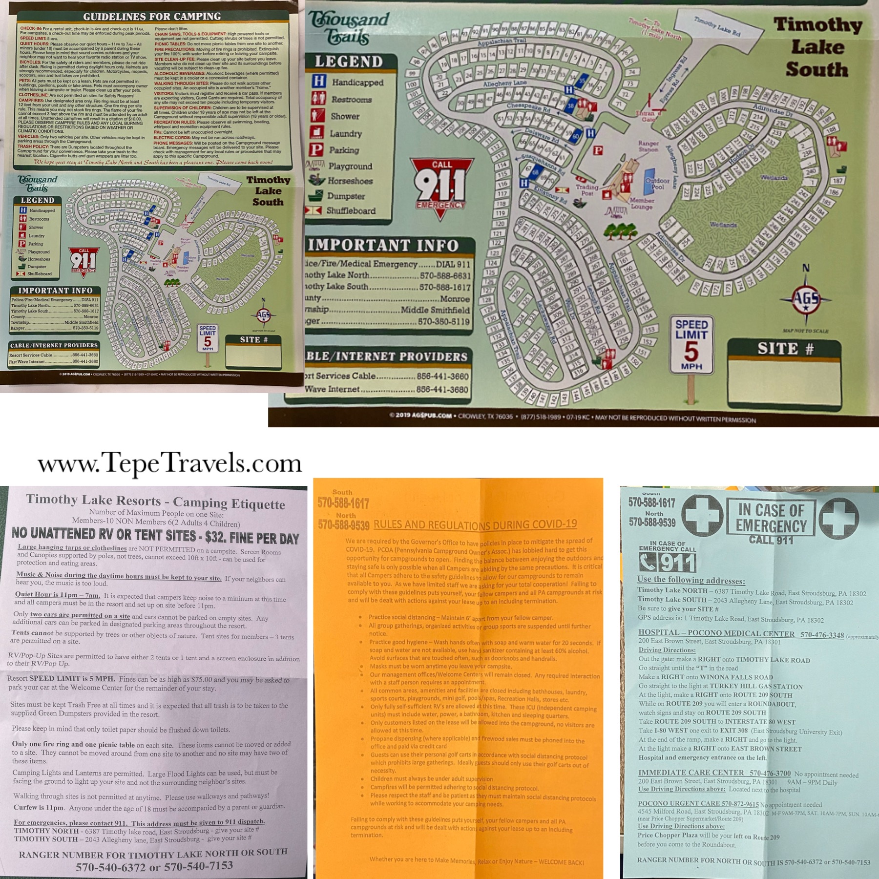
Have you ever heard of East Stroudsburg in Pennsylvania? We hadn’t either! We stayed in Timothy Lake South RV Campground in East Stroudsburg, in the Poconos.
The campground offered quite a few pull-throughs and some back-ins. The back-in sites seemed mostly along the edges of the campground. Many of the pull-throughs were very long. We could have stayed hooked up to the truck it was so long. They were a little on the narrow side though. There were plenty of trees throughout the campground, so once the trees have all their leaves, I’m sure it will be quite shaded.
Click to enlarge
The campground had a laundry room and office/store. However, the store was closed for COVID. You could walk up to the check-in window to buy ice ($3/bag) and firewood. The campground had a sister site, Timothy Lake North, whose amenities you could also use (per the website, we did not go).
Laundry was $2.00 for washers (or $2.25 for super wash) and $1.75 for dryers. The laundry room was limited to 1 person at a time and you had to check out the key from the check-in window. Reservations were not accepted. They did not have quarters/change machine, although the machines were quarter run.
Our Verizon, AT&T, and T-Mobile were spotty around the campground and the mountain areas. We ended up paying for the campgrounds WiFi for the week to make sure we could connect for work and school. Even their internet was spotty at times. It was also not a very fast internet.
The campground was 12 minutes from Super Foodtown grocery store and 16 minutes from Price Chopper grocery store. There were several restaurants within a 20 minute drive. The Delaware Water Gap was also close (12 minutes to a close trail or 25-30 minutes to the hike we went on).
Getting There: I would take it slow on these roads. The roads are pretty narrow to fit two cars (especially one being a truck and RV) around some of the turns. The roads are hilly and twisty as well.
If you enjoy quiet with no electronics and lots of nature and hiking, you may enjoy this location. However, everything was closed in the campground (not including the laundry room) and there was just not a lot of things to do besides hiking (or kayaking if you had your own). We would not stay here again. If things were open, maybe it would have been a different experience.
SUMMARY OF CAMPGROUND:
Our rating: 2 out of 5 hitches
Cell Phone Reception: AT&T, Verizon, T-Mobile (all of our connections were slow/spotty depending on where we were in the park)
Laundry: Yes
Bathrooms/Showers: Yes
RV Sites: Pull-through and Back-in (grass)
Pop Up Tents/Gazebos/Outdoor Rugs On-Site: Yes
Amenities: picnic table/fire pit/grill at sites, playground, pool (closed for season while we were there), shuffleboard. (Paid for cable and WiFi)
Cabins: Yes
Tent Camping: No (sister site Timothy Lake North does)
Full Hook-ups: Yes
Amps: 20/30/50
Pool: Yes
Food On-Site: No
Camp Store: Yes, closed due to COVID
WiFi: No free WiFi, Paid WiFi (a little slow, not what I would call high-speed internet)
We’ve moved to Pennsylvania and although pretty, there were not many activities close to the campground except hiking.
For Mother’s Day, we headed to the Delaware Water Gap National Recreation Area to go on a hike. The Delaware Water Gap is an elongated park, and we were hiking to Mount Minsi, which was towards the bottom of the park. The park had several hiking trails and a beach area.
I used our trail app and found the Mount Minsi via Appalachian Trail hike. It was supposed to be 5 miles, listed as moderate, and followed part of the Appalachian Trail. Ben has wanted to hike part of the Appalachian Trail for a while, so we wanted to take advantage of the fact that it was pretty close by (about a 30 minute drive). I looked at the pictures and thought it didn’t look too bad and it had great reviews. (Spoiler: I was wrong.)
The trail was a lot more crowded in on the way up than we expected. There was a small parking lot by the trailhead that was almost completely full. There was also a smaller lot a little up the hill, which was also full. I thought that on Mother’s Day, that it wouldn’t be that busy, but I was wrong. It still wasn’t super packed, but still had about 30 people pass us.
Now, I know I already gave the spoiler that I was wrong about the trail difficulty. Our hike ended up being 5.6 miles (Ben’s tracker said 5.8 miles and I did accidentally pause the recorder at one point on mine, so somewhere in that range) with an elevation gain of 1086 feet. My theory was that people were too busy trying not to trip and fall that they didn’t take pictures of the hard parts for their reviews. 😉 The trail was mostly a loop, which we always like in a hike. It started as an out and back, then splits to the right and left. We ended up taking the right side of the path, which probably is the only reason we finished the hike. The left side was a lot more narrow, rockier and had more climbing (at least for my shorter legs) over rocks. Either way, you are climbing uphill and coming downhill on the way back.
Parts of the trail
There are bears in the area, so we did bring our bear spray. We did not see any though. We heard birds, but the only wildlife we saw were several millipedes along the trail. We looked them up when we got home and discovered they were the ironworm/American Giant Millipede.
The top of the trail has two lookouts, and I would recommend seeing both since you are already there. The first overlooks a neat rocky hillside and has a nice space to sit and take a break. The second lookout also has a few nice large rocks to overlook the Delaware River.
Views along the trail
I’m glad we did it, although we (especially the adults) were exhausted at the end. Ben and I were sore even the next day. Hikes like this one make me miss having a tub to soak our feet in!
DETAILS:*
TICKETS: Free, except for beach or river access. COVID Restrictions: Visitor Centers closed, masks required
HOURS: Most is open 24 hours, per website
PARKING: Yes, but some lots are small
BATHROOM: Not at trailhead. Visitor Centers are closed, although we did see a bathroom that was open on the other side of the Bushkill Meeting Center.
TIME RECOMMENDED: 1-4 hours
*Details correct at the time of posting, but please double check before you go.
This preserve is tucked back in among farms and private residences. hiking, saw a few farms/peacocks/sheep, nice view of the bay and lighthouse. We heard a few birds, but didn’t see that many. We did see a skull of some kind along the path and a few white tail deer rain in front of us.
We went to check out Assateague Island based on the recommendations from the Pearl Market. The park spans the border of Maryland and Virginia. We decided to go to the Virginia side, as it was closer. The Virginia part of the park is also the Chincoteague National Wildlife Refuge.
We stopped first to see the beach (Atlantic Ocean) and the Visitors Center. The Center was closed, but they did have maps, passport stamps, and a Ranger there to ask questions. The park has hiking trails, the beach for swimming (does not always have a lifeguard), and allows fishing/crabbing.
Virginia fences the horses to keep them away from roads, which is good but also means that the horses are farther away. At times, it seemed like you were just looking at a farm/ranch’s fenced in horses. Maryland does not fence the horses, so they do wander into the road, etc.
We did a couple of hiking trails (the Woodlands and Lighthouse). Both trails were either nicely paved, a boardwalk, or pretty even dirt paths. The Woodlands trail wandered through the woods and had a few areas to view the horses if they were nearby. The Lighthouse trail had a vault toilet and a parking lot, and (surprisingly) led to the lighthouse. The lighthouse was closed, although you could walk around it. The one thing I wished they did was put the trail lengths on the maps. There was a map at each trail head sign, plus the ranger gave us a trail map at the Visitor Center; however, neither of the maps, nor the app, had the trail lengths listed. When I looked later, I did find the trail lengths on a separate website. We had a nice time walking around.
We did not get to the Wildlife Loop, as it is pretty long and we would have had to wait for a couple more hours to drive it. It is open only for walking or bicycles until 3:00 pm. After 3:00 pm, you can drive the Loop.
We had a pretty mild day, but in the summer I would bring lots of water, sunscreen, and bug spray. The Ranger told us the mosquitoes are horrible when it gets warmer.
DETAILS:*
TICKETS: Included with Interagency Pass (America The Beautiful annual), or $10/1 day, $25/7days. There is also a refuge annual pass option and a beach parking pass option. COVID Restrictions: masks required/social distancing. Visitor Centers closed, lighthouse closed.
HOURS: Park hours vary based on season. January-March 15th 6:00 am-6:00 pm, March 15th-April 6:00 am-8:00 pm. May-September 15th 5:00 am-10:00 pm, September 15-October 6:00 am to 8:00 pm, November-December 6:00 am to 8:00 pm. The Visitor Center also has different hours of operation.
PARKING: Yes
BATHROOM: Yes
TIME RECOMMENDED: 1-3 hours
*Details correct at the time of posting, but please double check before you go.
Although it is very pretty to look at the Chesapeake Bay, we normally aren’t ones to just sit and stare at the ocean. We found a couple of hiking trails/boardwalks/paths in the area. The first one we tried (other than the great Wildlife Refuge) was the Cape Charles Natural Area Preserve.
This preserve area was a little weird. The parking lot was right next to a Fuji company building and it also bordered on a construction site for parts of the trail. There were two paths you could take at the small parking lot. To the left was a boardwalk that went over a pond. That one was a little boring. To the right was a dirt path that changed into a boardwalk. It went through the woods, where it also branched into two paths. The left path went through the woods and ended with a small seating area. The right/straight path meandered parallel to the construction site for a little bit, and also led to a view of the Bay. There was no beach access however, as the boardwalk stopped a little before the sand.
We heard some birds in the woods, but didn’t see a lot of animals along the paths.
I would definitely bring bug spray during the warmer months. I would also take my time on the boardwalks. There were several boards that were loose or felt a little soft, as well as sections that seemed to sway when we were walking on them. It wasn’t a bad trail area, but it was a little boring.
Kiptopeke State Park was a nice little state park near Cape Charles, Virginia. It had a small swimming area, a fishing pier, and a few hiking trails. There was a campground, cabins for rent, and a nice picnic area (with a restroom).
Map, self-service admission booth, observation landing by picnic area, office and little library
We had a lovely sunny day to explore this park. We brought a lunch with us and sat in the gazebo for a picnic lunch before setting off for exploring. We wandered down to the fishing pier where we saw the Chesapeake Bay Bridge-Tunnel, and some old pier pilings, and an artificial reef made from old WWII ships (they are made of concrete!). There were a few kayakers and fishermen out. My absolute favorite part of the park was seeing dolphins in the Bay. We saw about 4 of them swimming and cresting out of the water. We hadn’t seen any dolphins yet on this, even with all our ocean visits. I was happy we got to see them.
Dolphins, pelican, birdConcrete Fleet ships making up a man-made reef.
The hiking trails led you among the woods, along the coast, and by fields for butterflies. We came across several offshoot trails that were not on the map, so just pay attention to where you are.
It was a great hike and worth the $7 we paid to get in. As a bonus feature, there was a Little Library by the office!