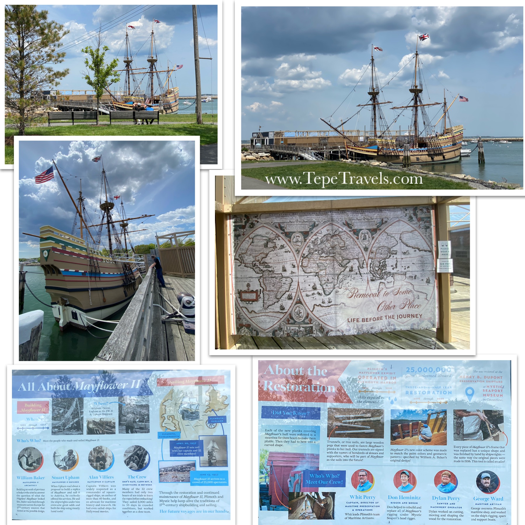
Plymouth Rock is located in Pilgrim Memorial State Park (Plymouth, Massachusetts). The park was about a half hour drive from our campground. The park is free and you can see both Plymouth Rock and the Mayflower II just from walking around. There is a charge for the Museum and to go on the Mayflower II.
Will was very excited to see “THE ROCK”. His grandparents did try to warn him that it wasn’t as exciting as he thought it would be.
It was indeed, just a rock. There was a pavilion placed over the top of it to help protect it from the elements. The rock was identified as “the rock” 121 years after the pilgrims landed. Plymouth Rock was later split during the Revolutionary War and the one piece was moved to the town square for “liberty” inspiration. The two pieces were later reunited in 1880. The claim on the informational board that the original rock the pilgrims may have seen was 3 times larger; I guess due to weathering and splitting of the rock?
The Mayflower II is located in the park as well. It is a reproduction of the original ship, with some modern technology thrown in. The ship was smaller than I thought it would be. There were not informational signs, much to Will’s dismay, but there were employees throughout the ship to answer questions and to tell you information. There were 102 passengers on board with their animals, plus crew (20-30).
click to enlarge
We learned that the ship did not have a wheel to steer, instead it used a whip-staff to move the tiller, which moved the rudder. The crew worked in 4 hour shifts and kept track on peg board called a Traverse Board. The navigator also marked the knots on this board. It’s pretty amazing that they made it across the ocean without a wheel and only using a compass! Will was also shocked that they were not attacked by pirates, as King James ordered all his ships to be painted in brighter colors (yellow, red, blue, green).
The town is really cute with lots of shops and food options. We had a beautiful day for walking around.
We went to Yorktown with our friends who were visiting for the weekend, the Piatt’s. I can honestly say that I don’t think any of us had high expectations (except for Will). However, we were pleasantly surprised. The Visitor Center was partially open for the bookstore/gift shop. The store had the passport stamps, but did not have any pieces of paper to use if you forgot your passport (or use in your journal like we do). You could buy a sticker sheet for $0.95 (+tax) to stamp though. All the kids got a Junior Ranger Program booklet to work on. A lot of the museums and houses were closed due to COVID, but there is a free audio app that you can download. The app has some information on different sites in town, as well as the two driving tours.
Monument, Visitor Center
We walked into the town from the Visitor Center using a nice paved path. It wasn’t a long walk; I think they said 456 yards. We saw the Statue of Liberty, not to be confused with the one in New York. It was a super cute little town with some shops and a coffee shop, and the Historical plaques that Will had missed seeing in Williamsburg.
We stopped at the artists shop at York Hall and found a few nice pieces. Ben found a colorful quilt. It was History Day, so there were a few demonstrations in the front of the Hall, including some children’s games.
We walked down to the waterfront and saw the beach area. There were a few sections of beach and a fishing pier. It was pretty crowded, so we didn’t get near the water.
There are two driving tours you can take in Yorktown: the red (Battlefield, 7 miles) and the yellow (Allied Encampment, 9 miles). After circling back to the Visitor Center, we got into our cars and took the red driving tour. I had downloaded the audio app, so we were able to go to each stop, park in the lot, and listen to the tour. There are parking spots, so you can also get out to look at things and read the historical informational signs.
Yorktown was a neat area with a mix of history, beach fun, and shopping. It ended up being one of my favorite places to visit while in Williamsburg. (In fact, we went to the town twice!)
DETAILS:*
TICKETS: $15/adults, $0/child (ages 0-15), Free with Interagency or Annual Pass. COVID Restrictions: masks required, some buildings closed
Hey guys, this is another blog post by Will! Today I am here to talk about the amazing world of Historic Williamsburg! We visited Williamsburg with our friends the Piatts and had a great time. To start out with you will want to park your car, and then walk to the left of the building towards the side. You might see a shuttle there and if so you can get on that to get over to Historic Williamsburg. If not, you can take the path up ahead which is the cooler option in my opinion. You can see the plantation they recreated which includes a windmill that not only has rotating blades but the body also rotates as well to get more wind flow. The body part had to be manual though.
Once you get to Williamsburg you can explore whatever you want. A lot of the stores and shops are open and it is free to walk around if you haven’t decided on buying a ticket yet. We had prepaid for tickets however so we were good to go. We skipped the governor’s house right off because of the huge line and instead went to a historic house which had been left standing for all those years. It had a parlor, a guest bedroom, an office, and a socializing room on the first floor. In the back they had sheep and the kitchen. This was also where we saw our first tradesman a cooper. Williamsburg has many occupations in the town which make all of the different things that they sell and even construct some of the buildings. The coopers for those who didn’t know, were people who made buckets and barrels by putting iron rings around individual pieces of wood.
After we left the house we started wandering towards the armory, looking at all of the different things around the town. Once we got there we first saw the shoemakers. They, as you can probably tell, make shoes and told us all about it. The lady in the front was very helpful and told us that a skilled shoemaker could make 1 shoe in a 12-hour day. She also told us master shoemakers were expected to make 7 shoes in 6 days. She said that most men wore black shoes because they were the fashion of the day and that they were also easier to keep clean and fix. There was more variety in women’s shoes with some being made of different material and colors, but for men it was mostly black leather shoes.
Next, we went to the blacksmith which was right next to the shoemakers. There was another woman standing there with two men in the shop, one pumping the bellows and the other using a file on some tool. She told us that the most common item they made was farm equipment, but during the Revolutionary War they also made many weapons for the war cause. She said that to make the metal soft enough to mold you needed it at 1,000 degrees Fahrenheit and to get it really hot enough you needed it at 2,000 to 2,600 degrees Fahrenheit. During her talk the two guys in the back pulled out a red-hot piece of iron and started pounding at it with their hammers which was pretty cool. She said that the metal they usually used was iron and steel which was pretty common in the United States so they didn’t require it to be imported during the war. I also found out later in the tour that the blacksmith also makes nails which are used in the construction of some of the buildings at Williamsburg.
Top Row: Capitol Building. Middle: 1771 building, shoemakers, Nick getting pressed penny. Bottom: blacksmith’s
After that we went to explore and came across some bathrooms and a shop. We all took turns going to the bathroom and also went inside to look around the shop. Nick got a pressed penny with the Capitol building on it. We also went to a nearby restaurant where we bought root beer, diet coke, and bread and ate it at the nearby benches. Then we went to the Capitol Building which was the seat of government in Virginia. It was hit by lighting, burned by people, and destroyed 3 times. On the last time they moved the capitol away where it promptly burned down again. The court ruled on large cases like murder, counterfeit, and robbery. You could choose to have a case by either peers or the magistrate which was a group of judges.
After the Capitol building we visited the jails where prisoners could be kept for 3 months (or more) before they were tried before the court, as the court only met during certain times. They also kept sheep and horses in the back which we later learned were used by weavers at Williamsburg to make clothing and yarn which you can buy at the gift shops.
We then visited the carpenters where we learned they made their own tools and build many of the buildings made of wood that are around Williamsburg. They told us that it took thousands of shingles to make the building they were currently under. They used nails from the blacksmith shop, which I thought was very cool. They even had a storage area in the attic of the building above them. They said they were going to soon construct a group of buildings and he pointed to a pile of wood which at the time I thought was a trash pile and said those were 8,000 shingles and that they needed 20,000 shingles for the whole project. At that I was impressed.
We then visited the shop that sells all of the homemade goods for Williamsburg where I learned what all the trades were at Williamsburg. They have weavers, coopers, silversmiths, blacksmiths, and carpenters for both buildings and furniture. We took a look around and saw an old toaster (which was pretty cool) that had been made by the blacksmiths.
We then visited the grandest building in all of Williamsburg, the Governors Palace. And it was a palace indeed! In the entrance were hundreds of swords and guns for both infantry and cavalry. It had a huge courtyard and two other buildings for the kitchen and one for the slaughtering of animals. It had a ballroom and a reception area, and enough guns to supply a regiment of soldiers. It even had different musical instruments in the back and a huge emblem on the back door. It had a grand back area for a garden. We did the maze with various finishing times for the group.We walked around a little longer and then went home.
Sarah Note: Bottom Right: Steps. We saw these stairs everywhere with metal bars in them. I asked the tour guide what they were. Back in the day, there were not always slabs under the steps, which could make for some wonky stairs. After the stone was placed, a spot was carved out, molten metal poured in, and a metal pin placed in to help hold the stairs together.The maze at the Governor’s Palace Gardens
And that’s the end of the blog with Will. Don’t forget to like and subscribe to the blog, and to follow our Twitter, Facebook, Instagram, and YouTube. See you soon, Will!
SARAH NOTES: Williamsburg was open to Visitors, although it was recommended that you buy your passes online. You have to choose your date of attendance when you book your tickets. Parts of Williamsburg is free; you can walk through the town and shops without paying the admission fee. However, if you want to go into certain areas or houses, then you do have to have an admission ticket. (For example, Governor’s Palace, carpenter’s yard, Wythe House.) Due to COVID, they are limiting the amount of people inside the buildings, so you may be waiting in line for awhile. I think our longest time was about 45 minutes. They call themselves a living history museum, so Will was a little disappointed in the amount of historical plaques to read. He made up for it by asking the blacksmith and shoe shop several questions though. We saw the Wythe house, the blacksmith and shoe shop, the carpentry yard, and the Governor’s Palace.
If you missed the Instagram video, here is a link to our video at the Blacksmith’s and seeing some adorable baby sheep.
DETAILS:*
TICKETS: Several options available. Single Day $35.99/adults, $19.99/child (6-12) . COVID Restrictions: masks required, book online for a set date, Visitor Center Closed, social distancing at some locations so you may wait in line.
HOURS: Hours vary. Most of the shops are open 9:00am to 5:00pm, but there are some evening programs based on the day.
PARKING: Yes, Visitor Center (with shuttle or a 1/4 mile walk) or at art museums
BATHROOM: Yes
TIME RECOMMENDED: 2-4 hours
*Details correct at the time of posting, but please double check before you go.
Hey guys! Here’s another blog post with your favorite friend…Will! Today I am here to talk about another significant site from history, the Jamestown Settlement. This is the first settlement that successfully settled in America. It was led by Captain John Smith, who as most of you know befriended Pocahontas. She convinced her father to help the settlers, which allowed the first successful colonization in the New World.
Jamestown started out as a place to get rich quick. Half of the first people to come Jamestown were gentlemen, men who fought in battles and were rich enough to be able to buy their own armor and weapons and lead men. These men were used to fighting and tactics, but not hard labor which led many of them to dislike their new life in the Americas. It probably would have been a downhill spiral as the two groups of people, gentlemen and commoners, fought over who would do what work in Jamestown if Smith hadn’t stepped in and said if ‘you don’t work you don’t eat’.
Jamestown also suffered many problems when it was starting up such as the fact that they had settled in native territory and slaughtered the natives there which were a part of a confederacy of natives at the time. That soured relations quite a bit and soon the settlers and the natives were at each other’s throats. The problem was that most of the men were not used to hard labor and most were unskilled and did not know how to make anything or work. They only had two trained fishermen so their food was in short supply. The drinking water was also unhealthy and some of it was even tainted with arsenic. They were, under the guidance of John Smith, able to finally build the fort which was 1 acre in all, and with the help of John Smith, soon began to trade with the natives and with Pocahontas.
The next big issue that Jamestown faced was the Starving Time. This event was caused because the settlers got on bad terms with the natives again and trade soon came to a halt. With only 2 fishermen and winter coming things were getting dire. They were soon eating their dogs, their horses, and even their own people. The first person to be cannibalized in America was Jane, a young woman. Eventually two ships who had originally come with a large fleet of ships arrived right when the settlers were abandoning Jamestown to try and find food. Horrified by the skeletal people, the new people shared their food with them and they all sailed back to recolonize Jamestown. The first big issue was that, because most of the buildings were made of wood, they were quickly deteriorating. They soon rebuilt the wooden post-in-ground houses and rebuilt with stone bases so that termites and ants could not enter the wood and so the wood was not at ground level.
Soon things were looking brighter for Jamestown. They were soon turned into the capitol of Virginia because of a huge crop that was making its way to Europe as quickly as it could be produced. A cash crop that changed Jamestown from a desolate fort that was struggling for survival into a huge port city and the capitol of Virginia. Tobacco! The people in England couldn’t get enough of the stuff. It was soon being shipped out of Jamestown and making the whole town very rich. Soon the state of Virginia made it legal to only bring tobacco out of Jamestown so that Jamestown became even more rich. This caused Jamestown to grow huge in size and led to more indentured servants and then, sadly, slaves.
The downfall of Jamestown was when the capitol of Virginia moved to Richmond and the laws that tobacco could only go through Jamestown were abolished. Soon many were leaving Jamestown as the city was losing money, and without money, no people would come. Jamestown soon fell into disrepair and the only thing left standing over the years was the old church tower that had been built out of bricks. In the 1900’s conservation efforts were made. A seawall was built to make sure that the coast would not erode more, and restoration of the stone towers was attempted. At the time it was assumed that the erosion of the shoreline had made it so that the original fort had been lost to the sea. Excavation began and soon that was proven false as they found the original ditch for the fort, several wells and post in ground holes were discovered. They also found tools that belonged to a smithy and old waste and trash that was covered up in wells or in basements. This included a helmet, a halberd, and a dagger.
After several excavations the National Parks bought the land and Jamestown fort and took over construction of the fort. They added a museum and most of the things you can now see here today. That is the long and complicated story of Jamestown. Thank you for reading and make sure to look at our other channels like YouTube, and Facebook. Goodbye for now.
Sincerely,
Will
Ben and Sarah Notes: Don’t picture seeing a historic town like you would in Williamsburg. While it does have several buildings, Historic Jamestowne only contains a few original structures: the original church tower (since restored and the church recreated). a house ruin, and some foundations. The rest of the buildings are recreations. There was a lot of reading, including the more in-depth Junior Ranger Program booklet. The houses and archeology pits were closed, although the Visitor Center and museum were open. The boardwalk was nice way to walk into the town area. It passes over a marshy area where we saw lots of turtles in the water. There were a few turtles upside down, which we thought was bad. Nick asked the Ranger, and he replied that some turtles can turn themselves over and they may be sunning and trying to get more warmth through the thinner belly shell. Or, they didn’t make it through the winter. Ben and I did learn one new thing I don’t remember learning in school: there was a Starving Time (where food was scarce and the town resorted to cannibalism).
TICKETS: WITH Annual NPS Pass $10/adults, children 0-15 free. WITHOUT Annual Pass: $15/adult. COVID Restrictions: masks required, houses were closed to tours. (The extra fee, even with the NPS America The Beautiful Annual Pass, goes to Preservation Virginia.)
HOURS: 8:30 am to 4:30 pm
PARKING: Yes
BATHROOM: Yes
TIME RECOMMENDED: 1-3 hours
*Details correct at the time of posting, but please double check before you go.
We were actually driving around trying to find a post office with a package drop box when we realized we were close to Fort Moultrie and decided to stop and check it out.
The fort we saw was actually the 3rd one on the site. The first was constructed of palmetto trees and sand and was used during the Revolutionary War.
This is not how I pictured Peter Parker (aka Spider-Man)!
The fort was later rebuilt and was ultimately destroyed by a hurricane. The third fort was constructed and end up being used during the Civil War. This fort seemed to have a lot of it built into the ground. The Union forces stationed at Moultrie left to go to Sumter, as it had better defenses. Moultrie was defended against sea attacks, but not very well defended for a land attack. Of course, then the Confederates used Moultrie to attack Sumter and force the Union troops out. There was a battery to the left of the fort that was added later, but it was closed while we were there. There were a couple of the interior hall paths that went underground, although a couple were closed or very muddy when we were there.
There was some interesting information and we also got to drive by Sullivan’s Island Lighthouse, but I would not recommend this one unless you are nearby or really into Civil War history and/or forts. It was a little boring compared to the others.
The Junior Ranger Program booklets were available at the entrance, as well as a park map. Nick was excited he got to complete another badge.
DETAILS:*
TICKETS: $10/ages 16+, free ages 0-15, or included in America The Beautiful Pass. COVID Restrictions: masks required. Due to COVID, no cash is accepted at the Fort and the Visitor Center is closed. Tickets must be purchased online.
HOURS: Fort is open Friday to Sunday 9:00 am to 5:00 pm. Grounds and parking open 9:00 am to 5:00 daily.
PARKING: Yes, has its own parking
BATHROOM: Yes
TIME RECOMMENDED: 1hour
*Details correct at the time of posting, but please double check before you go.
Fort Pulaski is outside of Savannah, Georgia (on the way to Tybee Island), and about an hour from our campground. It is part of the National Park Service, so we were able to use our annual America The Beautiful pass.
It was similar to Fort Zachary in Key West, but had a few unique features to it including a moat and a drawbridge!
The Visitor Center was closed, although the bathrooms across from the Visitor Center were open. The Visitor Center had maps outside and there was someone there to hand out Junior Ranger program booklets and badges. There are also few hiking trails; however, only two were open when we were there. The ranger did not think the Lighthouse trail would be opening anytime soon. It seemed like nature was reclaiming the trail.
Visitor Center, informational signs, looking towards Fort Pulaski from Visitor Center
There was a moat around the fort, which was pretty cool. During the Civil War, the Fort was originally Confederate, but Union soldiers gained control. There was a small cemetery out front from when the Fort also acted as a prison for Confederate soldiers during the Civil War. Parts of the outside paths and trails were closed for construction. We entered the Fort on a boardwalk over the water and through the drawbridge.
One of my favorite features was the drawbridge and the amazing doors of the Fort.
The Drawbridge
The fort had lots of rooms and cannon exhibits open on the main floor. It also had stone spiral staircases leading up to the top floor. Most of this area was closed for repairs/construction and there was also no guardrail along the edge. It definitely gave you a different perspective of the fort and the surrounding area.
Views from the top of the Fort
Fort Pulaski still had some of the metal rails in the floor that guided the cannons. It was neat to see those, as Fort Zachary in Key West had similar markings on the floor of where (I assume) these metal pieces used to be. It was nice to see the “whole picture” of the cannon set up at Fort Pulaski. Pulaski also allowed us to see a couple new cannon accessories that we had not seen before; the casement gin and sling carts that were used to move the heavy equipment.
There was another really neat feature that we got to see at Fort Pulaski, the foundation and built in cisterns. The Fort is surrounded by salt water, so there were 10 built-in cisterns to collect rainwater.
During the Civil War the Fort also acted as a Prison for Confederate soldiers.
Some information when it was acting as a Civil War prison
DETAILS:*
TICKETS: Included in America the Beautiful (Interagency) Pass. If you don’t the America The Beautiful Pass, it is $10/person for a week pass (ages 15 and under free), or $35 for a Fort Pulaski annual pass. Cash was not being accepted at the gate, credit/debit cards only. COVID Restrictions: masks required, Visitor Center closed.
HOURS: 9:00 am to 5:00 pm
PARKING: Parking lot at Visitor Center/Fort.
BATHROOM: Yes, by the Visitor Center
TIME RECOMMENDED: 1-3 hours
*Details correct at the time of posting, but please double check before you go.
The WWII Museum is amazing. If you haven’t been there and are going to New Orleans for a little bit then you should visit this place. It has all sorts of cool exhibits, and artifacts about World War II. There are four main buildings which are the Louisiana Memorial Pavilion, the Hall of Democracy and US freedom Pavilion, the Solomon Theater Building, and the Campaigns of Courage building. We stayed here all day from about 10AM to 5PM. It was great, but if you don’t want to stay the whole day reading, I’ll explain all of the exhibits here so you can plan your trip.
Louisiana Memorial Pavilion: This area is where you sign in and get an introduction via a fake train taking you off to “war.” On the second floor is the Arsenal of Democracy which goes over some of the statistics and overall look at the countries their armies and their weapons. It explains more on the US home front. The third floor is the D-Day exhibits which have first hand accounts, weapons used, and a cool demonstration of one of the German lookout towers with a model instrument. The First floor also has a little history on The Higgins Boat and has a motorcycle and artillery gun near the side.
The Solomon Theater: We walked across this quickly and only saw a little, but it mostly consists of the movie theater, a fun, quick look at the marines and some of the supply ships the US used in the war and a gift shop.
Hall of Democracy: This is where we went for lunch at The American Sector Restaurant and Bar. It was nice enough and actually pretty nice for being at a museum. I got an Oreo sundae which was delicious and chicken and sausage gumbo. My dad got a double cheeseburger with fries. We also visited their special exhibit about the distraction part of the army that was made to keep the Nazis guessing and that made the inflatable tanks and guns. This exhibit was called Ghost Army the Combat Con Artists of World War 2.
Campaigns of Courage: This was really cool. The top floor goes over the process of taking down Japan and has a really cool building structure that first looks like a ship and then a jungle. The first floor goes over the defeat of the Nazis and looks like a desert and then the ruins of a city. This goes more in depth into the defeat of the Axis powers and has fun videos that go over most of the reading.
US Freedom Pavilion: This is a really cool exhibit that lets you see some of the vehicles used during World War II including a B-17E Flying Fortress called MyGalSal. It also has a jeep with a gun attached and an amphibious car that has a rifle rack in the front.
Outdoor statuesAdmission button (acts as proof of ticket), stylus for exhibits, Dog Tag card (You are assigned a person to follow at the beginning of your visit in the train. You collect information along the way and can review it later. You can even log on once you are home to read your experience.)Social Distancing Signs
DETAILS: *
TICKETS: Due to COVID, you need purchase tickets ahead of time for a timed entrance. Tickets are available online. Face coverings are required. There are several ticketing options, including private tours. The General Admission Tickets are $28.50/adult, $18/child K-12. There are discounts for military, seniors, college students. WWII Veterans and children under 5 are free. The Campus Pass includes General Admission and the 4-D Beyond All Boundaries movie. $35.50/adult, $25/child K-12, $7/child under 5. There are discounts for military, seniors, college students. WWII Veterans are free.
One of the things we wanted to see while in New Orleans was the Lake Pontchartrain Causeway. It holds the Guinness World Record of the longest bridge over water (continuously).
There was a toll on the north side of the lake heading south (back to New Orleans) for the bridge. The toll was $5/2 axles, or $3 if you had a toll tag. You could also take a different highway home to avoid the tolls, but it does add additional time to your commute.
When we went, it was a little overcast and cloudy. Luckily there wasn’t too much traffic on the bridge. The causeway has two bridges, one going North and one going South. Each side had two lanes. Around the middle of the bridge, there was a drawbridge to allow water traffic through, although we did not see it in action. The drive was fun. We saw a few birds roosting and a few motor and sail boats out on the water. At one point, we couldn’t see land in either direction! Lake Pontchartrain is large at 629 mi² and 39.77 miles in length, but averages only 12-14 feet in depth. VIDEO: Driving On Lake Pontchartrain Causeway from New Orleans to Mandeville (South to North)
Although the drive itself was our mission for the day, we also stopped at Fontainebleau State Park to stretch our legs. Admission was $3/person (daily), not the normal per car fee. The park had several offerings: campground, cabin rentals, playground, beach, walking trails. We headed to the Visitor Center first and learned some interesting information about the park. It was at one point a sugar plantation and was named Fontainebleau by its owner after a park in France. Located in front of the Visitor Center were the remains/ruins of the sugar mill. They were fenced off with a short picket fence, but they are in bad shape, so be careful walking near them. The Visitor Center had a campground map that had a park map printed on the backside. The Visitor Center was smaller, but worth a stop if you are in the park.
The windows looking out had an etching of the sugar mill. It is a little hard to see in the pictures though.
We drove down to the beach and it looked like a soft sand. There were alligator caution signs throughout the park. The beach also had a nice large parking lot, several picnic bench areas, and a large building with changing stalls, showers, and bathrooms. There was also a pier you can walk out onto, located at the beach area.
Walking trail to Marsh Boardwalk
It was a little muddy, so we only took the shorter trail near the beach area to the marsh boardwalk. We saw a few birds and ducks, but no alligators. It was a nice enough park, but I wouldn’t go back for more than one visit with the entrance fee. I would definitely prefer to go Barataria Preserve to get a look at bayou type of areas. However, their rental cabins did seem nice and were right on the water, so it would be a nice place to stay. (Click here for my Barataria post.)
Fontainebleau Park Details:
TICKETS: $3 per person for daily pass
PARKING: Lots of parking at beach, Visitor Center and near trails
One of the reasons for going on this trip was to learn/see new things and to expand the boys’ views of the world. We wanted them to be able to think and research, listen to both sides, and come up with their own conclusion, to not just take everything at face value.
The museum is in a really neat building and is the oldest continually running museum in Louisiana.
DETAILS:
TICKETS: Due to COVID, you need to email the Museum to make a reservation for the day/time you want to visit. You pay for your tickets once you arrive ($10 adults, $5 kids ages 7-14). It was only open Thursday to Saturday when we were in New Orleans.
PARKING: Pay parking on street or nearby lots
BATHROOM: Yes, downstairs
TIME RECOMMENDED: 1-3 hours
The museum is on the main floor of the building, with the bathroom downstairs. They had some neat pieces of history on display. It was mostly reading with one video. There was a small gift shop as well.
We started on the left side of the museum and one of the first exhibits we saw contained a Dix! New Orleans has history to the city. Being on the water, the city had plenty of trading with ships coming and going. At one point, the city was separated into French and American sides. Canal Street separated the French and English speaking parts of New Orleans. Each side had their own currency (French bills and American/English). Per our tour guide at Sazerac House, people met in the middle of Canal Street to do business, as it was considered neutral ground. One bank there decided to create a new currency, the Dix (French for 10). It was printed in English on one side, French on the other, and was a $10 bill. It later was nicknamed a Dixie, and hence the name for the South was created.
Battlefield trees with shrapnel embedded Top: Uniform and gloves of Daniel Merwin. He lost his right arm in battle. His “Invalid Fork”, and 2 Left Hand gloves. Bottom Left: Sucession Badge image.We find the mention of Ohio in the strangest places.Different artillery shells.Silver crown given to Davis, link of chain (boats), Stonewall Brigade Medal, Seal of the Confederacy
It was interesting to see this perspective on the Civil War. There were some signs that definitely had a Southern slant to the way they were worded. There was no real addressing the issue of slavery, it was mostly facts and information about battles, soldiers, and Jefferson Davis. It did give us a few good talking points to go over with the boys.
The gift shop was an interesting mix of wooden toys (chess board, 9 pins, chalkboard, Jacob’s Ladder etc.), hats and t-shirts, patches, stickers, quill pens, and the Confederate flag.
Chalmette Battleground and Cemetery is another part of the Jean Lafitte National Historical Park. When we were there, the Visitor Center was only open on the weekend. The park itself was open until 4:00 pm most days.
It is a battleground site. This was our first battleground visit on our trip. There is not a lot to see: a Visitor Center, the obelisk monument, a memorial urn statue, and a plantation house. If you climb the levy, you can look at the river. There is a nice paved walking trail around the monument to the house. There is also a driving path (I did see lots of people walking it too) that leads further back on the battlefield and to the cemetery.
Pano of the Park grounds
The Rodriguez Plantation house is still on the property, although the second story staircase is gated off with a danger sign. We saw that the second story balcony was missing several boards.
The Park’s grounds also contain a National Cemetery, although only 4 from the War of 1812 are buried there. I didn’t know until after our visit, but there is also an audio tour available by calling on your cell phone (number is 504-799-0803 per their website) and there is also a virtual tour.
Cemetery: Can be accessed by walking or driving on the “self-guided driving” path
As a side note: Will saw one of the paintings featured on an informational plaque at the park in his history textbook. He thought it was pretty funny that the image included in his textbook had a National Park Service plaque memo that the image was inaccurate, as the river “was not crowded with ships during the battle”.