Posted in: Exploring Ohio, Hiking, National Park, National Parks, Sightseeing

Cuyahoga Valley National Park

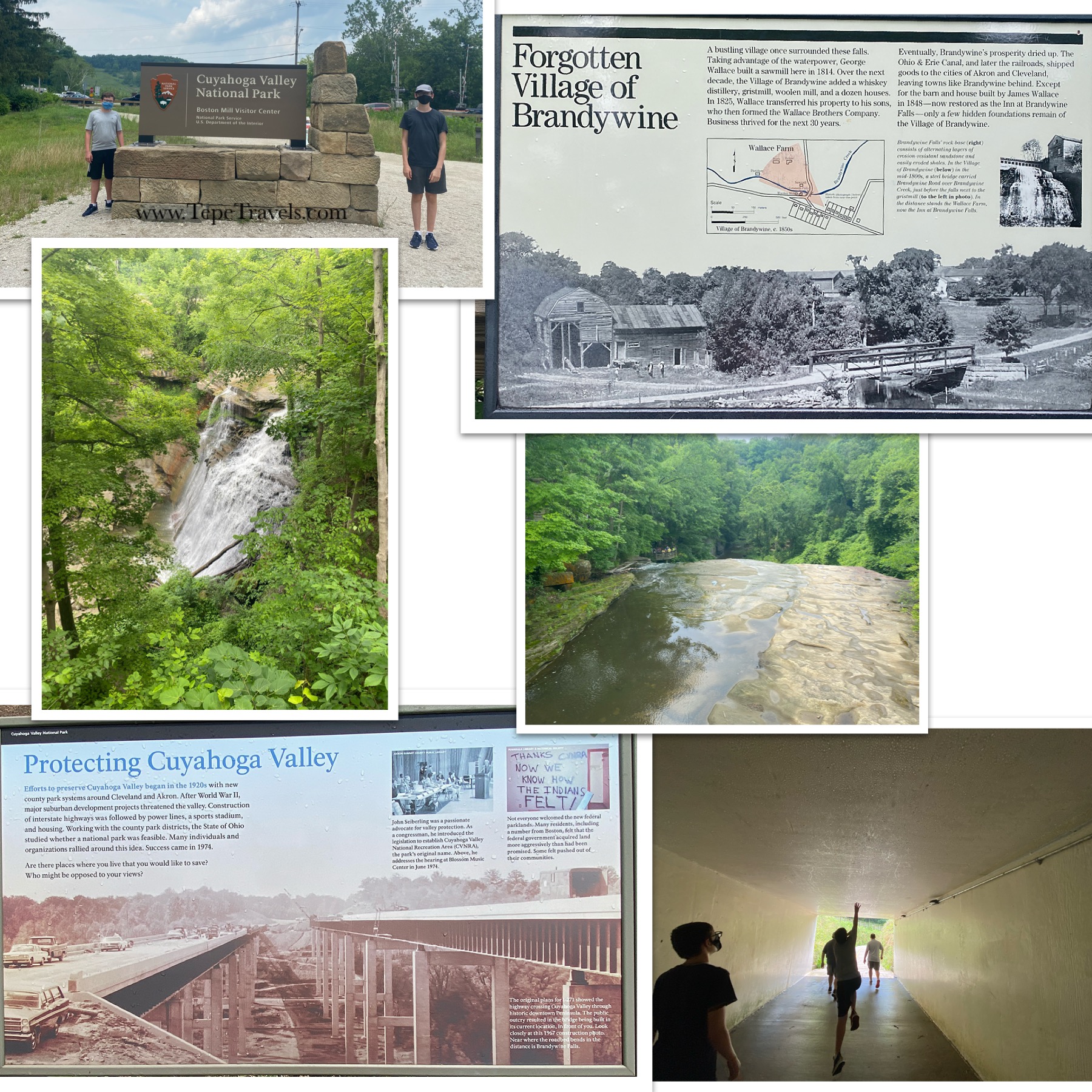
During our first stay back in Ohio in a year, we stayed up north near Cleveland. We visited the Cuyahoga Valley National Park. After the scenic train ride, we drove around for a little bit and stopped at the Boston Mill Visitor Center. This was a nice Visitor Center and the boys picked up their Junior Ranger books.

Maps via Google and NPS

Cuyahoga Valley is a little bit weird in its shape. It is a long, narrow park that exists around private property and state parks.

Cuyahoga NP Signs
click to enlarge

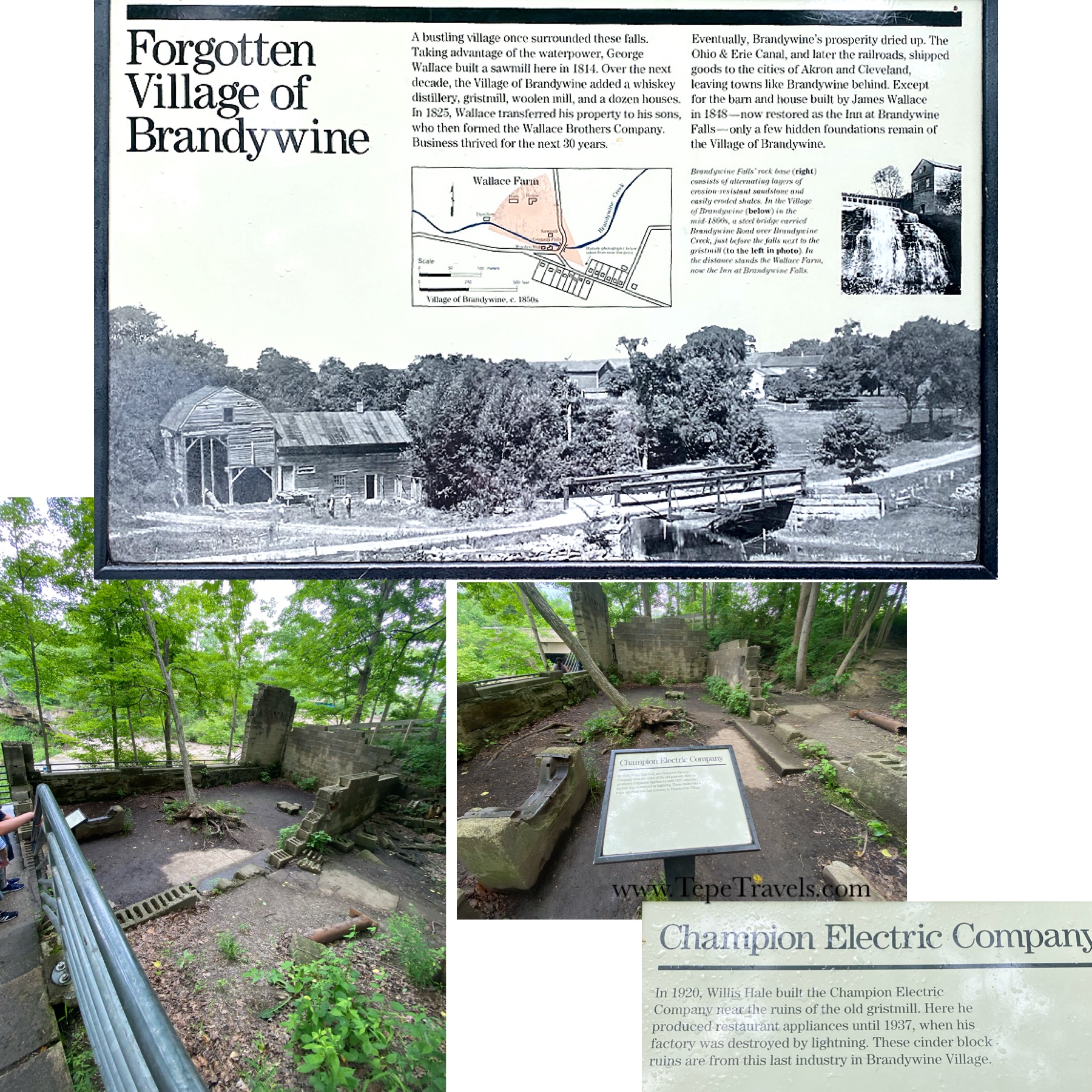
We went to the Brandywine Falls and managed to find a parking spot in the lot. We walked the boardwalk to the Falls. It was a beautiful area and you could see the remains of a small power plant. It was mostly just the foundations, but still neat to read about.

Brandwine and Champion Electric Signs
click to enlarge

It started to rain on us, so we head back home.

DETAILS:*

  • TICKETS: Free. Some activities have a fee. COVID Restrictions: masks required if not vaccinated
  • HOURS: Open daily
  • PARKING: Yes
  • BATHROOM: Yes
  • TIME RECOMMENDED: 1-3 hours
  • *Details correct at the time of posting, but please double check before you go.
Posted in: Animal Sightings, Exploring New York, Hiking, Sightseeing

Beaver Island State Park (Grand Island, NY)

We were out exploring the island and stopped at Beaver Island State Park. Normally there is an entrance fee, but there was a sign that said that since there was no attendant on duty, there was no fee. It was located on Grand Island, so it was just a short drive.

This park had a marina, a small beach area, a concessions area (only open on the weekends per the sign on the window), and a Frisbee golf course. The park also had a playground and picnic area by the beach.

It was a decent park, but there were a ton of flying bugs.

Bottom right: Bug swarm “cloud” in front of the trees
Posted in: Animal Sightings, Exploring New York, Hiking, Sightseeing

Buckhorn Island State Park

Ben and I took a “date day” walk at Buckhorn Island State Park. It was located on Grand Island, so it wasn’t far from our campground.

We took the Buckhorn Island Trail on the AllTrails App. The trail was about 4 miles long and ran along the water. The trail was nice and flat, although a little muddy in some spots due to recent rain. We saw a few butterflies, lots of birds, a few bunnies, and even a snake along the trail.

Most of the trail was pretty boring, as you couldn’t see the water. There were a few spots where you could see waterways. The highlight of the trail is definitely the at the tip of the jetty. You end up standing in the middle of the Niagara River with Canada on your left and Niagara/USA straight ahead and on your right.

Top photo: Looking back from where we came

NOTE: There was not a fee to use the park while we were there, but there are not any restrooms either.

Posted in: Exploring New Hampshire, Hiking, Museums & Tours, National Park, National Parks, Sightseeing

Saint-Gaudens National Historical Site

Will and I explored the Saint-Gaudens National Historic Site. This park was located across the river in New Hampshire, but was only about a half hour drive from our campground in Vermont.

Saint-Gaudens was a sculptor and the grounds contained information about his pieces and life. The house was closed, but the other buildings were open. I would not recommend this one for younger kids, as it was a lot of reading and not really interactive. There were some trails, including the Ravine Trail (which the Ranger told us was really more of a moderate path). However, since there was a heat advisory out (92℉), we did not do that trail.

The park also had a phone audio tour available, which was a nice feature to learn a little more about the pieces shown. Will completed the Junior Ranger program there, and they had a neat looking badge.

DETAILS:*

  • TICKETS: $10/adults, children 15 and under free. Can use America The Beautiful Pass. COVID Restrictions: masks required, House closed
  • HOURS: May 29-October 31 (9am-4pm)
  • PARKING: Yes
  • BATHROOM: Yes
  • TIME RECOMMENDED: 1-3 hours
  • *Details correct at the time of posting, but please double check before you go.
Posted in: Exploring Vermont, Hiking, National Park, National Parks, Sightseeing

Marsh-Billings-Rockefeller National Historic Park

Vermont has one National Historic Park, the Marsh-Billings-Rockefeller. The parking lot for the Park was across the street and is shared by the Billings Farm.

This Historic Park has 20 miles of trails and carriage roads (no bikes allowed, but does allow cross country skiing in the winter). The Mansion was closed while we were there and the Visitor Center only open for bathrooms. The Rangers did have a station outside of the Visitor Center for maps and Junior Ranger Programs.

Walking the grounds, Junior Ranger Loop

There were two Junior Ranger Programs: the traditional (received a wooden badge) and Change Maker (received a quarter made for the Park).

Mansion images, Junior Ranger program booklets/badge/quarter

It was a really hot day, so we only did the Junior Ranger loop and walked around the Mansion. The grounds are beautiful and I’m sure the trails would be amazing. It was so neat to learn from the Rangers about the quarter and that the Junior Ranger badge was made from wood located on the property.

DETAILS:*

  • TICKETS: Mansion tours were $8/adults, free for ages 15 and under (closed while we were there). Walking the grounds is free. COVID Restrictions: masks required, Mansion and Visitor Center closed.
  • HOURS: Trails dawn to dusk
  • PARKING: Across the street at Billings Farm.
  • BATHROOM: Yes
  • TIME RECOMMENDED: 1-3 hours
  • *Details correct at the time of posting, but please double check before you go.
Posted in: Animal Sightings, Exploring Vermont, Hiking, Sightseeing

Quechee Gorge

This was a neat spot to find. The Gorge is part of the Quechee State Park. You can park at the Gorge Visitor Center and walk to see the Gorge for free. I believe there is a small fee to get into the rest of the state park.

The Quechee Gorge was amazing to walk over. The bridge had cut-outs in the fencing to allow for picture taking. There were a few trails near the Visitor Center, including the one we took to go down to the river.

Views from the bridge of the Gorge

There were a lot of people hanging out near the river. Some had chairs that they placed on the rocks, others had picnics. There were both dogs and people swimming. We saw a frog, lots of tadpoles, a couple of small fish and crabs. The boys had shorts on, so they went swimming in the river. It was a hot day, so I’m sure it felt good.

The River. We saw a lot of tadpoles and the boys swam in the shallows.
Posted in: Exploring Maine, Hiking, Sightseeing

Hiking Maine: Salt Pond Preserve

One of our last trails of our stay in Maine was actually a trail outside of Acadia National Park. The boys got to pick form my list on AllTrails app, so of course they picked a short one at .9 miles. Following the AllTrails app directions, there was a very small parking spot off the road with only room for 1-2 cars. However, we later learned that there was also an access road with some parking options (Trail Map/Parking Options).

The path through the woods was an easy path, but had plenty of roots to keep an eye out for. Along the trail we saw a beautiful wild orchid called a lady’s slipper. The trail ended up on the water. We walked along the beach and saw some sea gulls eating a crab. We doubled the length of the hike by walking on the beach, which was really fun. The boys loved climbing on the rocks.

Posted in: Exploring Maine, Hiking, National Park, National Parks

Hiking Acadia National Park: Jordan Pond Trail

Ben and I walked part of the Jordan Pond trail on a date day, but it was a foggy, rainy day, so we didn’t get too far as neither one of us wanted to slip on the rocks.

A few days later, we walked the whole trail with the boys (about 3.4 miles). The trail is really nice and follows along the edge of the pond. Standing behind Jordan Pond House looking at the lake, the right side of the path is mostly dirt with a few rock step-overs for water run off. Eventually you cross a really cute bridge. A little bit after the bridge, you will come to the rocky section, where you have to climb over a rock path. This part of the trail is a little trickier, especially if the rocks are wet at all. After the rocky section, you will come to the boardwalk section of the path.

The boardwalk was not quite wide enough for people to pass each other, but there were wider sections for people to stand off to the side to allow people to pass.

It was a nice trail, and relatively easy. The scenery was beautiful as well.

Posted in: Exploring Maine, Hiking, National Park, National Parks

Hiking Acadia National Park: Beech Mountain, Loop Trail to Fire Tower

Will had so much fun by the end of the Valley View hike, that he wanted to go on another one. Luckily for him (not so much for Nick, who wanted to be done), there was another trailhead by the parking lot. This trail was also a Beech Mountain Trail, but it was a Loop Trail that went past a fire tower.

This trail was listed as moderate and was 1.2 miles long. I would agree that is was a moderate trail. The trail started on a straight path and then branched off. We went to the left, which I was glad we did. This part of the trail had lots of rocky areas and even hiking up a smooth rock surface. I think trying to go down that way would have been much harder than climbing up it.

The fire tower was really fun to see. It was locked off for the upper portion, but you could still climb the steps to the first platform and enjoy the view.

The way back down the mountain also had some amazing views. There were several rocky areas to sit on, so the boys took a rest while I got some pictures.

Posted in: Exploring Maine, Hiking, National Park, National Parks

Hiking Acadia National Park: Beech Mountain, Valley View

The boys and I ventured back into Acadia with a new trail in mind: Valley View to Canada Cliffs. Nick saw a picture on the AllTrails app reviews of a ladder and was very excited to climb it.

The trail was rated as easy (1.3 miles) and contained a dirt path with a few rocky areas and boardwalks. We never did see the ladder by the cliffs, even though we followed the trail map. Acadia had also placed blue paint markers along the path on rocks and trees, but some of them were very faded. Because of the uneven terrain in spots, I would say this was more towards the moderate side of the scale.

There was a view of the area below us, including a water view.

We had a little trail rage in the beginning by a certain teenager who didn’t want to hike, but in the end he enjoyed climbing over the rocks and finding his way along the path.

Back to Top
Cuyahoga NP Signs
click to enlarge
Brandwine and Champion Electric Signs
click to enlarge